A possible route, as shown on the Phaistos Disk.
Giving information about the route during the first part of the expedition the author shows us the way in which the priest determines the direction by means of a horn (horns) and the flying eagle. It must be possible to deduce the route from these pictograms, supposing that the priest was honest and didn't pretend. Probably he placed the horn in such a way that it pointed to the south, to the zenith of the sun and looking at the shadow he determined the east and the west. Perhaps the line on the right side indicates the season or the hour of the day, because it is not always in the same place nor of the same shape. As these people lived between the mountains they could not see the sunrise or sunset, so they were dependent on the knowledge of the priest. (Once at the coast they can see the whole firmament and are able to use the celestial bodies as their guides).
The priest must have acted as follows. First he determined the 4 points of the compass, next he looked at the direction in which the eagles were flying at that moment of the day in order to indicate the route in the same (or the opposite) direction.
If the eagle on the disk flies away from the horn he flies westwards, in the direction of the sunset, if he flies towards the horn, he flies eastwards, in the direction of the sunrise. From this one can deduce the following route.
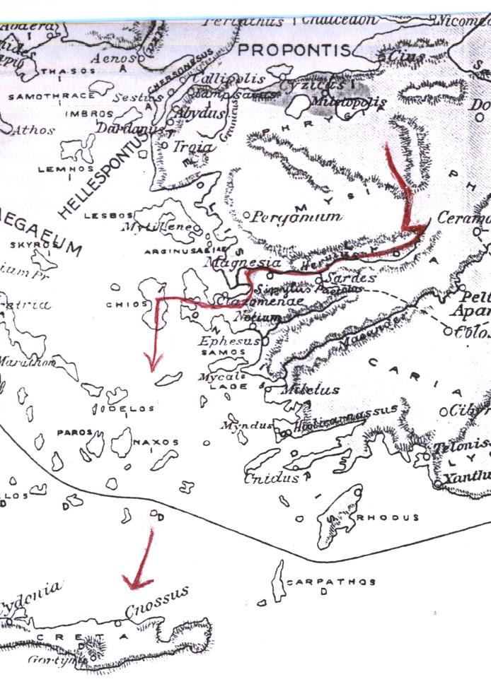
At first the group of people goes southwards with a slight deviation to the west (s. 7), then they branch off to the east (s. 10) till they end up in the turn of a river. This river runs from the east to the west into the Aegean Sea. Part of the group crosses the pasture-land (wet land) at the bank of the river to go on by boat (s. 11 and 12); the remaining group turns around and goes westwards following the river, as appears from the information that there is fish (s. 14). Finally this group also crosses the pasture-land (wet land) to go on by boat (s. 17 and 18). They go ashore in the neighborhood of the coast and walk another short distance to the south with a slight deviation to the east (s. 23) till they reach a peninsula (s. 25). Offshore there is an island, we name it Chios (s. 26). They stay several years on the peninsula (s. 28), before they take the risk to put out to sea. At sea they go south and navigating from island to island they end up in Crete.
According to this route the people could have lived in the interior of Anatolia (Turkey) at about 39° north latitude and 29° east longitude.There are of course other possibilities, as we don't know where they started and how long they travelled. May be they reached the coast a little more to the south, facing the isle of Samos, but I don't think they came from the south of Greece.
It is possible that in those days the sea-level was lower, so that there were more islands in the Aegean Sea, connected by spits of land.